Tuesday, October 8, 2013

C&O Trail to GAP Trail Bike Ride


Overview
We’re really blessed here in Western PA to have a lot of outdoor assets right in our backyard. The county parks system, the Laurel Highlands and numerous state parks are right out our backdoor. Pittsburgh also hosts the western terminus of the Great Allegheny Passage (GAP) which extends to Cumberland where it meets the C&O Canal Tow Path.  This past summer the final segment of the trail was completed making it possible to ride or hike from Pittsburgh to Washington, DC on a dedicated biking/hiking trail. Seemed like a great time to take advantage of some great fall weather and see the trail.

Getting There
Of course, in a point to point ride one of the big challenges is getting to the remote start or back from the remote finish. This is where mass transit comes in. Conveniently Amtrak runs passenger service from Chicago to Washington with stops along the way, including Pittsburgh. For $59 for a coach seat and a $10 charge to check the bike, it’s a very cost effective option. Packing the bike is easy. The bike boxes provided by Amtrak are huge. I only had to remove my pedals and turn my handlebar to fit in the box. (Note: New bike boxes are $15 unless you are ok with a used box which they will give you for free.)

Wrinkles
The trip was set weeks in advance and tickets purchased. No adventure is complete without some wrinkles and a few days before the trip the first adjustment in my plans came into view. The federal government shut-down meant that officially the C&O Trail was closed. However, my understanding was they could not stop people from entering the trail. With tickets purchased and time set aside, I decided to take a chance and go.


Just Left Union Station


Day 1
I arrived at train station at 4:30am and after boxing the bike I was told the train was running about an hour late. Nearly two hours later we were on the train and heading south. This was my first passenger train ride and it was very pleasant; much more pleasant than a trip by plane, however much slower also. By the time I got started in DC it was 4:30pm and about 4 hours later than I had expected . But I was well rested and ready to put in some miles before bedtime.

Getting on the C&O Near Georgetown


Great Falls Area North of Georgetown


After getting a few miles from Georgetown the crowds of walkers and bikers dissipated and the hot day cooled to a pleasant evening. I stopped to refill my bottles and noted that there were no handles on the water pumps at the C&O camping areas, a result of the government shutdown. Also steel straps were installed around the porta-pottie doors to prohibit their use. Given the number of Johns and pumps, I figure the FS personnel put in a couple of hard workdays shuttering the trail.

No NPS Means No Water and No Porta-Potties.
This sign and steel strapping were attached to each latrine.


I rode on into the night stopping at Whites  Ferry for water and dinner and eventually set up camp at Killiansbug Cave camping area with about 80 miles on the odometer. I was treated to a serenade by a couple of owls nearby hooting back and forth to one another.

Day 2
A bright clear morning dawned and fueled by Sheetz’s finest vittles I pedaled north. I was truly surprised by the geology of the area and the dramatic cliffs that flank the northern side of the Potomac. I was also awed by the effort of man to tame the river to make it navigable by canal boat. Huge reservoirs and lock systems were continuously in view and the Paw Paw tunnel was fantastic if not eerie. I hit the 176 mile marker at the 24hour point of the trip, which was my longest effort to on a bike to date.
Concrete Boardwalk North of Williamsport

Lots of Dams and Spillways Along the Potomac


I had first dinner in Cumberland and started the long climb to the Eastern Continental Divide as dusk fell. This section of trail requires a 20 mile uphill effort and crosses the Maryland/Pennsylvania state line in route to the divide. Following the summit a long cruise to Meyersdale lead to second dinner and more night riding and finally camp in Ohiopyle State Park.

Elevation Profile at the Eastern Continental Divide Crossing

Day 3
Again pleasant temperatures, albeit foggy and damp, greeted the morning’s effort and after a nice 25 mile morning warm-up, breakfast was ready at the Connellsville Sheetz. The morning dampness burned off in the late morning sun and a good headwind started up for the 60 mile run into Pittsburgh. I made it to Point State Park around 3:30 for a 47 hour total time to complete the point to point course.
Ohiopyle Station

View from Bridge North of Ohiopyle

Approaching the City
Requisite Bike Lift at Journeys End

Requisite Picture with The Duck
Summary
DAY 1 DISTANCE: 80MI (4:30pm start)
DAY 2 DSTANCE: 175MI
DAY 3 DISTANCE: 80MI (3:30pm finish)
TOTAL TIME: 47 hours

Post-Mortem (What I’d do differently)
There isn’t much I’d do differently. Overall my gear choices were solid and appropriate for the conditions. There were two items I’ll add to my gear list the next time I go: a bell and a map case. It’s really hard to say “On your left” over and over in pleasant tone. I tried many variations to make it sing-songy and upbeat but in the end I think a loud ding-a-ding of a bell would be far superior. You don’t need a map to navigate the trail, but some side trails to towns are not well marked or marked at all. So having the reference up all the time would have been helpful. I did miss one crucial water stop and had to go 30 miles with no water. Luckily my blunder happened in the cool of the day so I just got a little depleted.

Full set of pictures from the ride can be seen here:
http://www.flickr.com/photos/74146447@N05/sets/72157636213785816/
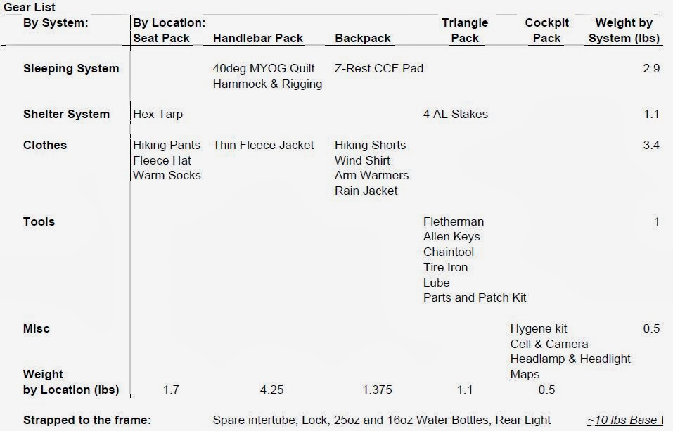
Gear List


Sunday, May 5, 2013

Laurel Highlands Hiking Trail Double Crossing - May 2013


Laurel Out and Back Report – May

Trail Overview

The Laurel Highlands Hiking Trail (LHHT) located in southwestern Pennsylvania is a 70-mile, point-to-point foot path that connects Ohiopyle at the south terminus to Seward (near Johnstown) at the northern terminus. It is a 100% single-track trail except for a short section of less than a mile that follows a gravel gas line access road.

The trail is a local backpacking favorite with three-sided shelters sites spread out at day-hike distances along the trail and reliable water sources along at known locations. The trail is also the backdrop to the Laurel Highlands Ultra, an annual point-to-point foot-race held each June.

The Challenge

Lacking a race or event on my calendar, I started looking for something to train for this past winter. I’ve found myself gravitating away from “races” recently and toward less formal fun-runs and challenges. After lots of brain storming, I finally settled on an unsupported long-distance foot-travel journey. Several venues were considered, but the eventual best contestant became the LHHT. Several different formats and dates were also tossed around in my mind and for various reasons dismissed until only one option was left standing: a self-sufficient double traverse of the LHHT.

History

I wasn’t the first person to take on this challenge. The original double direction LHHT traverse was completed by Art Moore on Memorial Day weekend in 1986. Art started and finished in Ohiopyle and his family provided aid at the road crossings and paced him through the night sections to a smoking fast 35:58:30 finish. Art’s monumental accomplishment was chronicled in an article in the September edition of Ultrarunning Magazine that year. I surmise that a thru-hiker or two have done a double traverse in a traditional backpacking format, but I have not found any documented accounts other than Art’s. (If anyone is aware of other successful attempts, please contact me or add a comment to this blog so I can get in touch. I’d like to include other pertinent historic information on this page.)

Philosophy

My approach to the challenge would be quite a bit different than that of Art’s in 1986. My attempt would be an unsupported effort whereas Arts’ was fully-supported effort. These terms have specific meaning in the long-distance foot travel community. (source: http://fastestknowntime.proboards.com/index.cgi?board=readfirst&action=display&thread=19)

Gear

An unsupported effort (sometimes called “alpine style”) calls for carrying all supplies on your person from the start of the event, except for water which may be obtained from native sources along the route. Self-sufficiency requires that the selected gear be adequate for the expected conditions (plus a safety factor). Here’s what I took:
Always Worn
Carried
Consumables
Sleeveless tech shirt
Home
4 Packs of Ramen noodles
Running shorts
MYOG 2.5Apex quilt
6 Packs of Oatmeal
Windshirt
Sleeping pad
4 cups of instant potatoes
Socks
Space blanket drop cloth
12 Cliff/Mojo bars
Shoes w/ gaiters
Wool socks (sleeping)
0.5lb Polish beef sticks
Visor
Flash 20 Basic Rucksack
2 Large Bagels
Rx glasses
Waterproof Pack Liner
20 Oreos/Sugar Wafers
Bandana
15 Reece cups/York PPs
Camera
Kitchen and Bath
2 Sleeves of Poptarts
Small  Bubble Compass
3 Waterbottles: 2L Capacity
2x 1oz Jiff "Nutella" clone
Cooking kit (including stove)
12oz Crushed Frittos
Sometimes Worn
Hygeine kit
4 Coffee "tea-bags"
Water Treatment Tablets
Clothing
Furnishings
Stove fuel for hot meals
Rain Jacket
Flashlight w/ spare battery
Med Weight LS Tech Shirt
Backup flashlight
Weight Totals
Balaclava and Watch Cap
Maps w/ notes
Worn: 4 lbs
1 pair Spare Socks
Vitriox knife
Carried: 5 lbs ("Base weight")
Light tech pants
First aid kit/Repair kit
Consumables: 5.5 lbs
Cell phone
Water (full capacity): 4.5 lbs

My gear kit was much more substantial for this effort than I would carry for a traditional ultra-event. The philosophy in an ultra-event is to carry just what is required to cover the distance between the aid stations and nothing more. I often describe the feeling of getting to aid at an ultra as “coasting in on fumes.” But this effort would be different. Instead of just getting by I wanted to take on this challenge with a self-sufficient style. In short, I wanted to thrive not just survive. Hence my gear looks like a “10-Essentials” type list and the items were specifically and deliberately selected to meet all the requirements of a long distance hike.
While this kit would adequate for an overnight trip or hike of up to a week long (with proper adjustments in the consumable category) in the warmer months and milder portions of the shoulder seasons, I wouldn’t consider this a true 3-season list. Notably missing from the list is a true shelter. For my double, I would use shelters located along the trail in the event of severe inclement weather. Otherwise, my sleeping system is designed for dry-weather, rough-camping on the forest duff under the stars.

The Effort

My hike started in Ohiopyle. After a hamburger at the Falls City Pub, I shoved off at 5:40p.m. hoping to get to mile 8 by sun down. On the climb out of OP I noted the flowering trees were in full bloom, but the leaves on the hardwood trees had not yet opened and the looked like little green tubes just poking out of their buds. The first evening’s effort went by very uneventfully. Water is easily located in the southern half of the trail. I carried 2L of water capacity, but due to the relative abundance in the southern section I was able to match the amount I had to carry in my pack to the distance to the next known source. In my research for this trip I located this list from a fall 2012 thru hike on Dane’s place (http://www.shol.com/featheredprop/)


At the "Brown Gate" the first time


After the sun when down a crystal clear and cloudless sky coupled with the still leafless trees made for a great star show as I hiked through the night. At about 4:30 a.m. I passed the 35 mile, mid-point and found a good place to bed down for the night just north of the trail mid-point. I found a nice rock to lay beside and spread out my bed roll and put on some warm clothes and sacked out. I woke at 6:00 a.m. as the sun poked up from the horizon still warm in my quilt, but knowing I needed to get moving. A breakfast of hot coffee and cold instant mashed potatoes jump started my engine. I also had a serving of Jiff Silk peanut butter and chocolate spread, which is my new favorite trail food, to eat with a bagel.


Stealth Campsite on the First Night
I made good time through the morning and focused on keeping my head up to see as much as I could. The LHHT has enough rocks and roots that at a jogging pace you have to keep your eyes on the trail, but moving at a steady hiking pace is much easier to keep your eyes on the scenery and the lack of leaves meant that the trail was less of a “green tunnel” than usual. As the day wore on the temps went up and I entered the driest part of the trail. North of route 30 there are no streams that cross the trail and the only water is from hand pumps located at the route 30 shelter area and route 211 parking area. Here I filled up on as much water as I could carry.

I made it to the northern terminus just before 6 p.m. A husband and wife were just packing up to hike out to the Decker Road shelter to spend the night. We chatted for a few minutes and I gave them info on the water situation on the trail. Their packs looked much heavier than mine and I was very happy that I did not have to climb to the ridge with that much gear. Just before sunset I stopped and topped off on calories for the night. Hot ramen noodles, instant spuds and Fritos made up my smorgasbord.

The second night was much harder than the first as I had a major fight with the sleep monster. It started with a groggy head started at about 10:30 p.m. and got progressively worse as the night rolled on. My pace slowed to a glacial trudge by 2 a.m., but I was determined not to stop till 4 a.m. I’d much rather hike in the cool of the night than the heat of the next day. Time seemed to slow down I as walked on through the dark and I deeply wished I had packed a 5-Hour Energy in my food bag. I did get to see two porcupines overnight which cool. I had heard that they are not frightful animals and this turns out to be true. The first one was ambling through some fern shoots. I shined my light on him he looked at me with a “I’m not afraid of you” over his shoulder and then turned and slowly walked off into the night. At 4 a.m. I found a nice place to nap near the Route 30 crossing and woke at 7 a.m feeling much better.

The hike from Route 30 south the next morning went well. With the cobwebs of sleep lifted, I resumed my power hiking pace making it to the well in Seven Springs by about 12:30 p.m. Just a marathon separated me from Ohiopyle and this section is the one I’ve spent the most time on over the years. I know this section of the trail well and it’s one of my favorites with lots of picturesque stream crossings and interesting rock formations that the trail snakes through.


By late afternoon I had only the 8-mile stretch just north of Ohiopyle (I call them the “Gate 2-8”) to go but they are the toughest 8 miles of trail in Western PA. The section features three really tough climbs the toughest of which is about 1,200 ft. My ears usually will pop when I go up or down it. As I was making the first decent I noticed something. The trees looked different than they had two days ago. The leaves that were tightly curled green nubs two days ago had partially unfurled and a tiny leaf was taking shape. The same overlook view that had looked barren two nights ago looked green and lush. It was a drastic change I had not expected. I watched my third sunset from the rock outcropping between mile marker 3 and 2. I checked my watch and noted that with a little hustle I’d make it in under 51 hours.

I strolled past the brown gate at the end of Garrett Street in the waning dusk and down to the Falls City Pub where I stopped. A guy sitting at a table with a beverage told me I looked lost. I told him I was looking for someone to take my picture and he offered to help. It was the perfect end to a great hike. It was not an epic an adventure. It was not dramatic but it was full of drama; a subtle drama that you can only perceive while moving down a trail in the spring at a walking pace.
Back at the Falls City Pub

I’ve posted all the pictures I took from the hike here and with some narrative and captions as appropriate. Enjoy:
I tried to keep this report short and sweet. If I missed a aspect of the trip you're interested in post a comment below or shoot me a message.


EDIT May 7, 2013: I'm adding the table with the numbers from the outing: