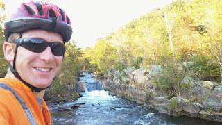
We’re really blessed here in Western PA to have a lot of outdoor assets right in our backyard. The county parks system, the Laurel Highlands and numerous state parks are right out our backdoor. Pittsburgh also hosts the western terminus of the Great Allegheny Passage (GAP) which extends to Cumberland where it meets the C&O Canal Tow Path. This past summer the final segment of the trail was completed making it possible to ride or hike from Pittsburgh to Washington, DC on a dedicated biking/hiking trail. Seemed like a great time to take advantage of some great fall weather and see the trail.
Getting There
Of course, in a point to point ride one of the big challenges is getting to the remote start or back from the remote finish. This is where mass transit comes in. Conveniently Amtrak runs passenger service from Chicago to Washington with stops along the way, including Pittsburgh. For $59 for a coach seat and a $10 charge to check the bike, it’s a very cost effective option. Packing the bike is easy. The bike boxes provided by Amtrak are huge. I only had to remove my pedals and turn my handlebar to fit in the box. (Note: New bike boxes are $15 unless you are ok with a used box which they will give you for free.)
Wrinkles
The trip was set weeks in advance and tickets purchased. No adventure is complete without some wrinkles and a few days before the trip the first adjustment in my plans came into view. The federal government shut-down meant that officially the C&O Trail was closed. However, my understanding was they could not stop people from entering the trail. With tickets purchased and time set aside, I decided to take a chance and go.
 |
| Just Left Union Station |
Day 1
I arrived at train station at 4:30am and after boxing the bike I was told the train was running about an hour late. Nearly two hours later we were on the train and heading south. This was my first passenger train ride and it was very pleasant; much more pleasant than a trip by plane, however much slower also. By the time I got started in DC it was 4:30pm and about 4 hours later than I had expected . But I was well rested and ready to put in some miles before bedtime.
 |
| Getting on the C&O Near Georgetown |
 |
| Great Falls Area North of Georgetown |
After getting a few miles from Georgetown the crowds of walkers and bikers dissipated
and the hot day cooled to a pleasant evening. I stopped to refill my bottles
and noted that there were no handles on the water pumps at the C&O camping
areas, a result of the government shutdown. Also steel straps were installed
around the porta-pottie doors to prohibit their use. Given the number of Johns
and pumps, I figure the FS personnel put in a couple of hard workdays
shuttering the trail.
 |
| No NPS Means No Water and No Porta-Potties. This sign and steel strapping were attached to each latrine. |
I rode on into the night stopping at Whites Ferry for water and dinner and eventually set up camp at Killiansbug Cave camping area with about 80 miles on the odometer. I was treated to a serenade by a couple of owls nearby hooting back and forth to one another.
I rode on into the night stopping at Whites Ferry for water and dinner and eventually set up camp at Killiansbug Cave camping area with about 80 miles on the odometer. I was treated to a serenade by a couple of owls nearby hooting back and forth to one another.
Day 2
A bright clear morning dawned and fueled by Sheetz’s finest vittles I pedaled north. I was truly surprised by the geology of the area and the dramatic cliffs that flank the northern side of the Potomac. I was also awed by the effort of man to tame the river to make it navigable by canal boat. Huge reservoirs and lock systems were continuously in view and the Paw Paw tunnel was fantastic if not eerie. I hit the 176 mile marker at the 24hour point of the trip, which was my longest effort to on a bike to date.
A bright clear morning dawned and fueled by Sheetz’s finest vittles I pedaled north. I was truly surprised by the geology of the area and the dramatic cliffs that flank the northern side of the Potomac. I was also awed by the effort of man to tame the river to make it navigable by canal boat. Huge reservoirs and lock systems were continuously in view and the Paw Paw tunnel was fantastic if not eerie. I hit the 176 mile marker at the 24hour point of the trip, which was my longest effort to on a bike to date.
 |
| Concrete Boardwalk North of Williamsport |
 |
| Lots of Dams and Spillways Along the Potomac |
I had first dinner in Cumberland and started the long climb to the Eastern
Continental Divide as dusk fell. This section of trail requires a 20 mile
uphill effort and crosses the Maryland/Pennsylvania state line in route to the
divide. Following the summit a long cruise to Meyersdale lead to second dinner
and more night riding and finally camp in Ohiopyle State Park.
 |
| Elevation Profile at the Eastern Continental Divide Crossing |
Day 3
Again pleasant temperatures, albeit foggy and damp, greeted the morning’s effort and after a nice 25 mile morning warm-up, breakfast was ready at the Connellsville Sheetz. The morning dampness burned off in the late morning sun and a good headwind started up for the 60 mile run into Pittsburgh. I made it to Point State Park around 3:30 for a 47 hour total time to complete the point to point course.
 |
| Ohiopyle Station |
 |
| View from Bridge North of Ohiopyle |
 |
| Approaching the City |
 |
| Requisite Bike Lift at Journeys End |
 |
| Requisite Picture with The Duck |
DAY 1 DISTANCE: 80MI (4:30pm start)
DAY 2 DSTANCE: 175MI
DAY 3 DISTANCE: 80MI (3:30pm finish)
TOTAL TIME: 47 hours
Post-Mortem (What I’d do differently)
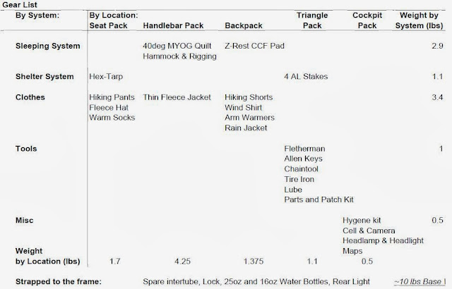
There isn’t much I’d do differently. Overall my gear choices were solid and appropriate for the conditions. There were two items I’ll add to my gear list the next time I go: a bell and a map case. It’s really hard to say “On your left” over and over in pleasant tone. I tried many variations to make it sing-songy and upbeat but in the end I think a loud ding-a-ding of a bell would be far superior. You don’t need a map to navigate the trail, but some side trails to towns are not well marked or marked at all. So having the reference up all the time would have been helpful. I did miss one crucial water stop and had to go 30 miles with no water. Luckily my blunder happened in the cool of the day so I just got a little depleted.
Full set of pictures from the ride can be seen here:
http://www.flickr.com/photos/74146447@N05/sets/72157636213785816/
Gear List

