Photodump: https://flic.kr/s/aHsmRqexrC
2020 has been a weird year: Covid and western wild fires conspired to upset all of my previous hiking plans. Times being what they are, I was in desperate need of some extreme social distancing on a trail.
This seemed like the perfect year to take on one of adventure projects:
The Standing Stone - Mid State Trail Boomerang route.
The Trails:
The Standing Stone trail is an 84 mile point to point trail that connects Cowens Gap State Park near Mcconellsburg to The Allen Seger Natural Area in Rothrock State Forest just east of State College.
The Mid State trail is a 327 mile point to point trail that bisects Pennsylvania extending from the Maryland to New York State line. The northern terminus of the Standing Stone trail occurs where it intersects the Mid State trail at Detwiler Junction.
The Route:
From Cowens Gap, the closest trail town on the Mid State is Everett which is just 30 miles west. This geographic coincidence was the genesis of the route as a personal project.
All-Trails Route: https://www.alltrails.com/explore/map/wed-30-sep-2020-12-34-eded070?u=i
As a matter of convenience for shuttling, I started my hike where the Tuscarora trail crosses route 30 near Top of Mountain roadhouse.
Facts and Figures of the Boomerang Route:
Distance: 172 miles (not counting side hikes to view points)
Vertical: 25,000 feet
Resupply: Food options directly on trail at Three Springs, Mapleton, Alfarata and Williamsburg
Trip Report:
I staged my vehicle in Everett and after the shuttle ride i was heading north on the Tuscarora trail by 8am. Potable water is available at Cowens Gap state park.
Just north of Meadow Gap is the start of a 6 mile road walk (urg) but the reward at the end is the full service town of Three Springs complete with a diner, pizza shop and convenience store at about the 30 mile point of the route. If you do this route in the reverse direction, the reward after the road walk is a long steep climb.
 |
| Monument Rock on the SST |
Between Three Springs and Mapleton, The Standing Stone trail is a mixture of forest roads, double track and single track. The pizza shop in Mapleton at the 52 mile point of the route is top notch.
North of Mapleton is the classic 1000 steps climb. Completing the climb to Shorb's Summit would be a worthy day hike with 1,600 vertical feet over 7 miles each way.
 |
| Sunset on Shorb's Summit |
After crossing route 655, the trail stays low through game lands and eventually reaches Roth Rock area. The trail snakes through the cool rock formations loved by local rock climbers for bouldering and top-roping. The trail connects to the high ridge where the follows a rocky route with numerous boulder fields before descending to Glen Furnace State Park.
The last section of Standing Stone summits Broad Mountain before descending into the Alan Seager Natural area where it intersects the Mid State Trail at Detwiler Junction.
Picking up the MST at Detwiler Junction the route turns south. From Rothrock to Alphrata the trail follows a single narrow ridge with exceptional views looking to both the east and west. The trail descends from the ridge at Alphrata where the Mid State trail follows the Lower Trail, a rail-trail, into Williamsburg.
A short road walk connects Williamsburg to the ridge and state game lands double track. The route stays on the ridge and crosses gas and power line cuts and eventually drops off the ridge into Loyalsburg gap before climbing steeply again to the ridge. The last section starts on grassy game lands double track and ends with rocky knife-edge ridge walk weaving through lots of fantastic rock formations.
The trails on this route are in fantastic condition and the route is well marked and well maintained. Both the SST and MST trail stewards have done an exceptional job on this trails. Its been a dry summer and fall but with a little forethought I never ran dry of water.
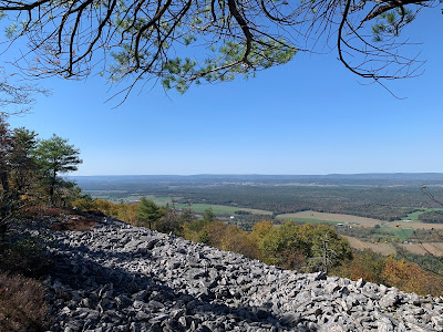
The highlight of this trip was the high ridge walking and fantastic foliage views with the town access and on-trail food taking a very close second.
If you wanted to do a light version of this route, connecting Alphrata and Mapleton would be an approximate 70 mile hike and would cover the best sections of the route and skip all the road walks. Rothrock Outfitters in Hundington does offer hiker shuttle services in this area.
So there it is: The SST-MST Boomerang Route. Go do it.


Amazing!!
ReplyDelete